Cargando...
Recursos educativos
-
Nivel educativo
-
Competencias
-
Tipología
-
Idioma
-
Tipo de medio
-
Tipo de actividad
-
Destinatarios
-
Tipo de audiencia
-
Creador
Lo más buscado
- El Alto Imperio romano
- Ejercicios de signos de interrogación
- Competencias básicas
- Proyectos escolares de fisica
- Experimentos para estudiantes
- Juegos geográficos
- Ejercicios escolares para niños de 4 años
- Términos geográficos
- Juegos de tablas de multiplicar
- Repaso acentuación
- Escritura pautada
- Rinoceronte
- Actividades de geografía
- Los demostrativos
- Centenas, decenas y unidades
-

ThingLink - Make Your Images Interactive
Jaume Feliu Docente
- 1 lo usan
- 1678 visitas
ThingLink lets users add interactive links to any photo and turn them into fun web experiences that drive engagement.
-

Interactive Map: Continents and Oceans
V&V Books Vicens Vives Organización
-
- 8 lo usan
- 3128 visitas
Use this interactive map to check your knowledge about our planet's continents and oceans.
-
-
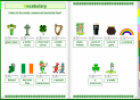
Interactive Book: St Patrick's Day
Tiching explorer Organización
- 1 lo usan
- 3331 visitas
The resource consists of an interactive book about the celebration of Saint Patrick's Day. We practice vocabulary related to St. Patrick's Day (symbols). We discover who was Saint Patrick. We learn what…
-
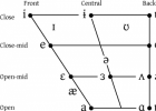
Interactive Phonemic Chart | EnglishClub SM
Francisco Cerrillo Docente
- 1 lo usan
- 1879 visitas
Click to hear each symbol and sample word. This interactive phonemic chart contains all 44 sounds used in spoken British English (Received Pronunciation).
-
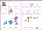
Interactive Book: Clothes and Accessories
Tiching explorer Organización
- 4 lo usan
- 2681 visitas
The resource consists of an interactive book. We practice vocabulary related to clothes and accessories people wear. We compare present simple and present continuous tenses. We improve oral and written skills.
-

L’oreille coupée: une BD interactive
Tiching explorer Organización
- 2146 visitas
“L’oreille coupée” es un cómic interactivo creado por André-Philippe Coté y Jean-François Bergeron.
-
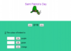
St. Patrick's day interactive quiz
Tiching explorer Organización
- 1 lo usan
- 1389 visitas
Set of 10 questions to check our knowledge about the celebration of Saint Patrick's day. The resource includes a text to search for information.
-
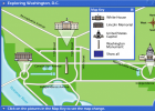
Interactive Map: Exploring Washington, D.C.
Suzanne Teesdale Organización
- 748 visitas
Interactive map to practise interpreting a street map and using cardinal points.
-
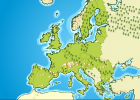
Interactive map of European Union
Suzanne Teesdale Organización
- 677 visitas
Interactive map of European Union that provides information about member countries.
-
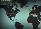
Inside World War II Interactive.
Carolina Diéguez Organización
- 883 visitas
Pàgina interactiva del nord-americà History Channel. Un mapamundi ens situa sobre tres escenaris bàsics: els Estats Units, Europa i Àfrica i Àsia. Fent "zoom" sobre qualsevol dels tres, es…


Te estamos redirigiendo a la ficha del libro...
